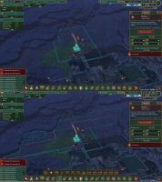
Show current district limit w/o paths AND show max district range
When selecting a district center it would be nice to be able to see the maximum distance achievable for a district using some kind of patterned grid and then maintain the green border that currently exists to show the current district reach achievable with your present path network.
As it stands, such as in my screenshot, the only way to see how far your district can reach is by extending its actual reach via paths.
Comments: 4
-
24 Oct, '21
FoxWas writing up essentially the same request!
I especially would like to have the ability to see the overlap of districts similarly to how beehives work. -
25 Oct, '21
Yappy1188I'm not sure this aspect of this idea is included, so I'll add it here. When PLACING a District Centre, it would be lovely to see its potential range in order to achieve an optimal placement.
-
01 Apr, '22
WhiteRoo MergedCurrently the district center helpfully shows how far beavers will go to build structures or collect resources. Please add a second range marker that shows how far beavers could theoretically reach, considering roads are also built.
Currently I can infer this information by laying down roads and check where the line ends, but this only works if the roads are continuous. This would help a lot with planning out districts. -
03 Apr, '22
Gin Fuyou Admin"Draw maximum district size when District Center is selected" (suggested by WhiteRoo on 2022-04-01), including upvotes (1) and comments (0), was merged into this suggestion.
