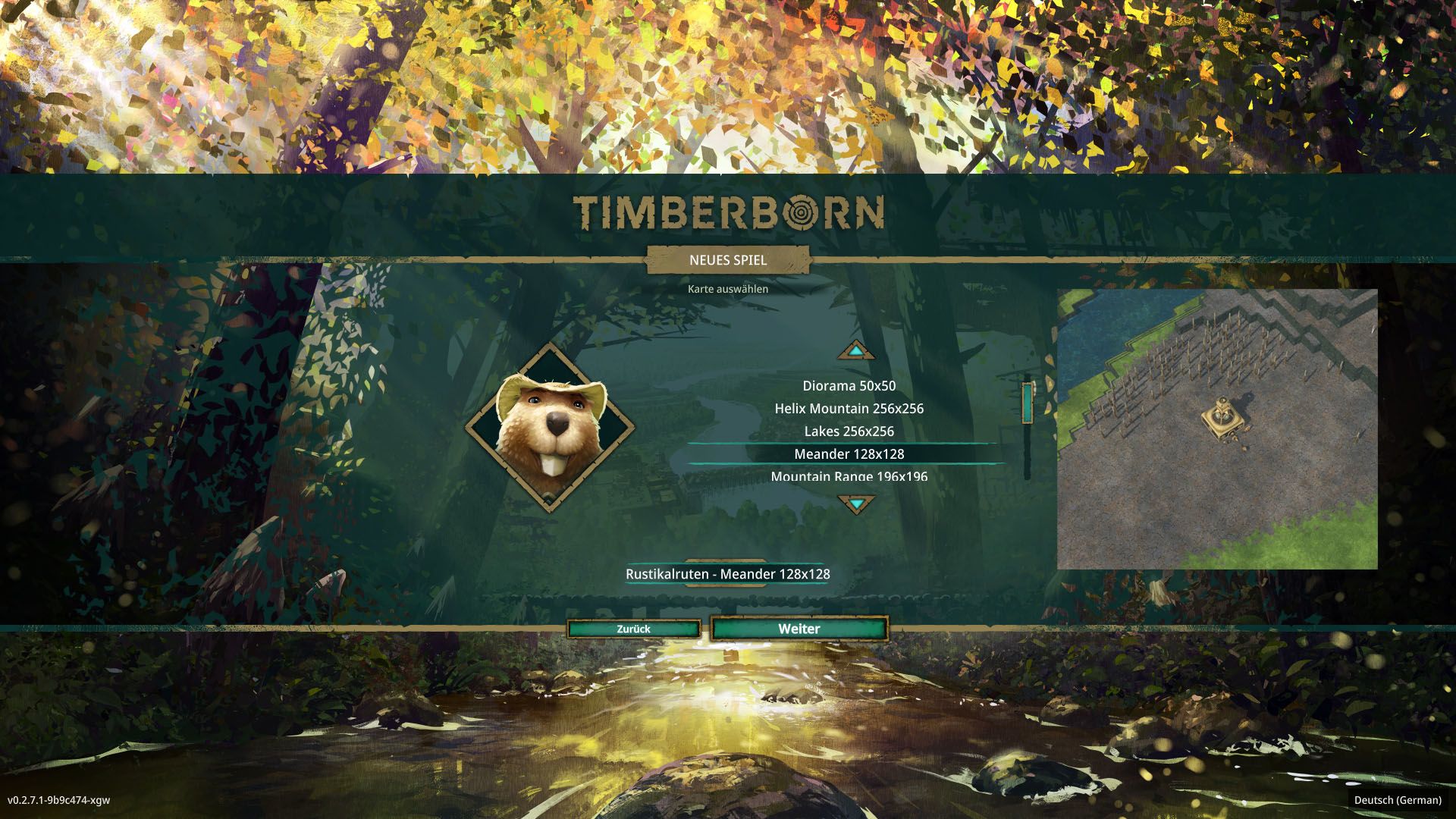
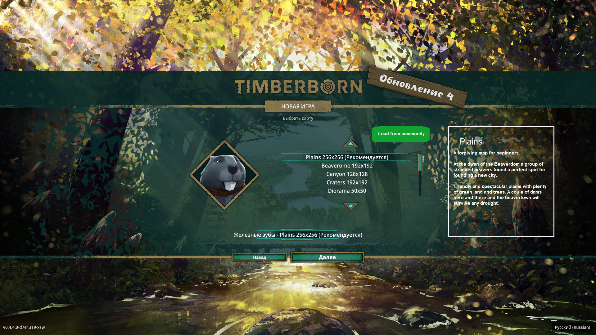
Map previews, attachable and automatic
To better understand map layout when choosing a map force editor to make an aerial screencap of the map on save and also allow adding one or two user-made images if one wishes to highlight some features.
[Suggested by @DirtyGambit]:
Add a description of what to expect in the map:
- Amount of rivers/water area
- Number of rivers/lakes etc
- Amount of elevation change
- Amount of grass land available at the start
Comments: 60
Oldest
•
Newest
•
Most likes
•
Fewest likes
-
16 Sep, '21
pmduda System"Map Descriptions" (suggested by Rebecka on 2021-09-16), including upvotes (1) and comments (0), was merged into this suggestion.
-
16 Sep, '21
pmduda System"Map Preview" (suggested by Joe on 2021-09-15), including upvotes (1) and comments (0), was merged into this suggestion.
-
20 Sep, '21
pmduda System"Add a map preview on the map selection screen" (suggested by Robert from Poland on 2021-09-20), including upvotes (1) and comments (0), was merged into this suggestion.
-
20 Sep, '21
pmduda System"preview mode for editor" (suggested by John j Vegar on 2021-09-19), including upvotes (1) and comments (0), was merged into this suggestion.
-
20 Sep, '21
pmduda System"New Game - Map preview" (suggested by Soan on 2021-09-19), including upvotes (1) and comments (0), was merged into this suggestion.
-
21 Sep, '21
CarlI honestly enjoy the game but I spent about 4 hours looking at all the maps, and then played waterfall and canyon a few times, and I have to say I'm straight up not going to play this game with the current mapset. It looks really cool, but I don't want to spend dozens of hours to repeat cycle after cycle of just gathering materials to try and have enough stuff to have fun with the water dynamics. Give us some maps with clear goals. I feel like I'd be completely sick of playing by the time I have the resources to go make a, say, dedicated science district. Or make an on-damn lumber processing area. I could be daft, but if feels like the maps are designed to be like "can't get down there!" or "the other side is too low!" when you're in early game trying to make a plan.
-
26 Sep, '21
DirtyGambit MergedWhen starting a new game, we need to know what the map looks like before starting it or even a description. I should not have to make multiple maps seeing if I like it before starting a map.
May be good to have a image or video showing off the map
Add a description of what to expect in the map:
- Amount of rivers/water area
- Number of rivers/lakes etc
- Amount of elevation change
- Amount of grass land available at the start -
26 Sep, '21
Gin Fuyou System"New Game Start Map image" (suggested by DirtyGambit on 2021-09-26), including upvotes (1) and comments (0), was merged into this suggestion.
-
22 Dec, '21
Gin Fuyou System"選択マップのプレヴュー" (suggested by 凰呀 on 2021-12-07), including upvotes (1) and comments (1), was merged into this suggestion.
-
13 Feb, '22
Zam! AdminI think it's not even necessary to force anyone to do anything. The map file has all the info necessary to generate a preview or a mini map.
-
03 Apr, '22
razer882 MergedI found myself starting a few new maps without knowing how they looked and if i already played them throught.
-
04 Apr, '22
Gin Fuyou System"A preview picture of the map you´re choosing when starting a new game" (suggested by razer882 on 2022-04-03), including upvotes (1) and comments (0), was merged into this suggestion.
-
09 Apr, '22
Farmagician Mergedplease can you add the ability to see the map (thumbnail) before choosing at the start of a new game
-
09 Apr, '22
Gin Fuyou System"please add" (suggested by Farmagician on 2022-04-09), including upvotes (1) and comments (0), was merged into this suggestion.
-
15 Apr, '22
osets Mergedwhen starting a new map being able to see the map layout in the map selection screen would be nice, along with maybe starting water coverage, resources , etc.
-
16 Apr, '22
Gin Fuyou System"Map Pictures" (suggested by osets on 2022-04-15), including upvotes (1) and comments (0), was merged into this suggestion.
-
22 May, '22
CostiHaving a map preview when starting a game would be just wow. I usually have to start and go back 1-3 times before I find a map I like.
-
19 Jul, '22
Andrew MergedI can see what each of the maps look like using the map editor.
When starting a new game, after selecting the faction, I would like to be able to launch something like the map editor in "view only" mode for each map, to be able to preview the map prior to my selection.
Without this feature, I find myself jumping back and forth between map editor and new game menu frequently, as I try to decide which map to play, and remember which one I wanted. -
21 Jul, '22
Gin Fuyou System"Map Preview during game selection" (suggested by Andrew on 2022-07-19), including upvotes (1) and comments (0), was merged into this suggestion.
-
09 Sep, '22
plupper MergedWhen you start a new game you have to chose a map you want to play. At the moment you see the name and the map size. Especially when you have added more maps than the official ones it is hard to remember which map is which.
Therefore I suggest that - when you preselect a map- a preview of the map is shown. This could be for example an isometric shot of the starting position covering a 32x32 area.
The preview will make it much easier to select the map that you wanted.
-
10 Sep, '22
Gin Fuyou System"Map preview by start" (suggested by plupper on 2022-09-09), including upvotes (1) and comments (0), was merged into this suggestion.
-
20 Sep, '22
tyler Mergedhave a preview image of the map on the select map screen so you aren't picking a map blind
-
21 Sep, '22
Gin Fuyou System"Show map on select map screen" (suggested by tyler on 2022-09-20), including upvotes (1) and comments (0), was merged into this suggestion.
-
05 Dec, '22
Kevin MergedWhen selecting a map, have a preview on the empty space to the right, or something.
-
08 Dec, '22
Gin Fuyou System"Map preview" (suggested by Kevin on 2022-12-05), including upvotes (1) and comments (0), was merged into this suggestion.
-
17 Dec, '22
John MergedWho nice if you get a picture next to the card name, how the selected card looks approximately in the end. So that you do not have to try through all first.
-
21 Dec, '22
Gin Fuyou System"Map display when creating a new game" (suggested by John on 2022-12-17), including upvotes (1) and comments (0), was merged into this suggestion.
-
30 Dec, '22
Jess MergedPlease add in a screenshot picture of each map when scrolling for selection as it is dificult to know what each one wiil look like just by the title.
-
01 Jan, '23
Ladislav MergedIt would be a lot simpler to choose (as a casual/new player), which map to play if there was some sort of "minimap" in the selection menu showing miniature version of the map.
I persnaly came back to the game after few months and had no idea which map do I want to try. People can still create world and see for themselfs, but this could save few new worlds being created just for the sake of choosing the most desired map for the run. -
02 Jan, '23
Gin Fuyou System"Adding Screenshots of the map before selection" (suggested by Jess on 2022-12-30), including upvotes (1) and comments (0), was merged into this suggestion.
-
03 Jan, '23
Gin Fuyou System"Map ovierview in menu" (suggested by Ladislav on 2023-01-01), including upvotes (1) and comments (0), was merged into this suggestion.
-
11 Jan, '23
Paul MergedWhen choosing a map in which you want to build your colony, you really want to see where exactly you are settling in
-
11 Jan, '23
SirMichael System"Pictures in the map selection menu" (suggested by Paul on 2023-01-11), including upvotes (1) and comments (0), was merged into this suggestion.
-
17 Feb, '23
A.Patt MergedOld school game of StarCraft and most after that have a mini-map layout of the level you are about to choose. This would be rather helpful when starting out as a new player or even a veteran player that wants to make a wise choice on a map for the goal of the player.
-
24 Feb, '23
Jcheung System"preview maps with image before selecting to start" (suggested by Ross on 2023-01-28), including upvotes (1) and comments (0), was merged into this suggestion.
-
11 Mar, '23
Gin Fuyou System"Layout mini map pictured on the level selection splash" (suggested by A.Patt on 2023-02-17), including upvotes (1) and comments (0), was merged into this suggestion.
-
03 Apr, '23
San MergedWhen I choose a map I would prefer to see what it looks like instead of starting 3 games and deleting them again until I find a map I like.
-
11 Apr, '23
SirMichael System"Add map preview" (suggested by San on 2023-04-03), including upvotes (1) and comments (0), was merged into this suggestion.
-
13 May, '23
Anton MergedIt would be nice to have a description and/or image of a map you are selecting. Sometimes you just don't know or don't remember what to expect.
Browsing community maps is self explainatory.
-
20 May, '23
Gin Fuyou System"Add map descriptions and community map browser to map selection menu" (suggested by Anton on 2023-05-13), including upvotes (1) and comments (0), was merged into this suggestion.
-
07 Jul, '23
Max Mergedwhen you are making a new game when your hovering over a map there is top down picture of the map it would be really helpfull
-
07 Jul, '23
Jcheung System"map photo" (suggested by Max on 2023-07-07), including upvotes (1) and comments (0), was merged into this suggestion.
-
21 Jul, '23
Peter MergedIt would be nice in the title screen to show a thumbnail of the maps before we load them. The description isn't enough to know what a map is like
-
27 Jul, '23
Gin Fuyou System"Maps" (suggested by Peter on 2023-07-21), including upvotes (1) and comments (0), was merged into this suggestion.
-
18 Sep, '23
Beaver MergedWhen Selecting the map when creating a new game add a could we get a vague idea of the map
-
18 Sep, '23
Gin Fuyou System"Could you add a screenshot of how the map looks when creating a new file?" (suggested by Beaver on 2023-09-18), including upvotes (1) and comments (0), was merged into this suggestion.
-
26 Sep, '23
Jcheung System"Preview maps" (suggested by blackice504 on 2023-09-26), including upvotes (1) and comments (0), was merged into this suggestion.
-
24 Oct, '23
chris Mergedwhen selecting maps, a thumbnail on the side with representative layout would be helpful